Gardening and Plant Hardiness Zones

A guide to understanding gardening zones and plant hardiness zones

GARDENING

3 min read

Since then, changes in temperature and weather patterns related to increasing global temperatures and greenhouse gas emissions have led to increased variations in climate. However, the gardening zone map is still a useful tool for gardeners to get an initial sense of their climate. As you continue to garden over time, pay attention to your environment and take note of any changes or particular patterns that you notice for your microclimate.

Where to Find Your Gardening Zone

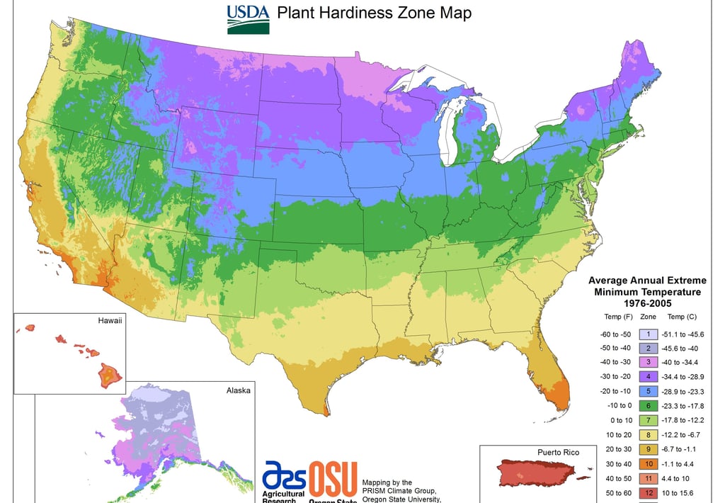
You can download a map of your region and plant hardiness zone at the USDA’s plant hardiness website.

Other Things to Know: Frost Dates

Other than gardening zones, it can be helpful to know the first and last frost dates for your location. The first frost date is usually sometime in the fall. “Frost date” refers to the first time that the temperature will drop below freezing during the night (which allows dew to turn into frost over night). The last frost date refers to the last night in the spring when the weather drops below freezing and conditions allow frost to form. The frost dates usually mark the beginning and end of the summer growing season. It’s important to know the frost date because frost can be deadly for both young crops and some crops that are ready to be harvested.

For example, tomatoes that are transplanted outside before the last frost, and tomatoes that haven’t been picked by the first frost, may not be likely to survive. However, for some crops it’s more beneficial to pick them after there has been a frost, because the cold will help the plant concentrate sugars. This is generally true for root crops, such as carrots and beets. Perennial or biennial crops (perennials are plants that can survive year round in a given climate, and biennials are crops that take two growing cycles to reproduce) can survive throughout the winter, but that is not the case for annual crops.

The farmer’s almanac allows you to search for the predicted first and last frost dates for a given city or zip code in the United States, based on historical data.

Have you ever heard of gardening zones (also known as gardening hardiness zones), but weren’t sure what that meant or how to find out what zone you live in? This post will cover everything you need to know about gardening zones, including an overview of their history and how they first came about, gardening zone maps and how to find out what gardening zone you’re in, the characteristics of each type of hardiness zone, why hardiness zones are helpful for gardeners, and a few other pieces of information that you’ll want to find out to help get you started with your own garden.

What are Gardening Zones?

Gardening zones, or hardiness zones, refer to areas (or zones) where climate conditions are relatively similar, as a way to help gardeners understand the climate where they live and know when to plant their crops. Gardening zones originated in the United States in 1927 and there are eleven total hardiness zones. Hardiness refers to a plant’s ability to survive in stressful growing conditions that are less than ideal.

Understanding the climate conditions and a plant’s hardiness is important because it can tell gardeners what types of plants will survive in their garden year round, and what time of year to plant annual plants as well. Plants that will survive from year to year and continue to grow need to be able to tolerate the conditions in your hardiness zone throughout the entire year. These plants are well adapted to the amount of rainfall in your zone and both the coldest and hottest temperatures.

What’s the Origin of Gardening Zones?

Gardening zones are somewhat unique to the United States, but the overall concept can be applied to any climate in any region around the globe. Zones tell us the general climactic conditions of any area, which will determine what types of crops can survive in that zone.

Gardening zones originated in 1927 at the Arnold Arboretum at Harvard University in Cambridge, Massachusetts. That year, a taxonomist (a biologist who specializes is in the classification of organisms named Alfred Rehder published a book called the Manual of Cultivated Trees and Shrubs Hardy in North America. Included in the text was a map of the United States that had been divided into temperature zones, which were used to show the geographical range in which different types of plants would be most likely to thrive. The original map divided the continental United States into eight distinct temperature zones. The map has continued to be revised in the years since as new data around temperature and climate becomes available.

The United States Department of Agriculture (USDA) produced their first plant hardiness map in 1960. In 1990, the USDA map was revised and for the first time included Canada, Mexico, and both Alaska and Hawaii, all of which were areas that had previously been excluded from the hardiness zone map. The USDA’s hardiness zone map was last updated in 2012, using data for the twenty-nine years that preceded 2005.